Wanderkarte MN-23, Cindrel 1:60.000
Südkarpaten
€9.90
incl. VAT
in stock
Delivery in 2 to 4 business days
Tags
südwestlich von Hermannstadt
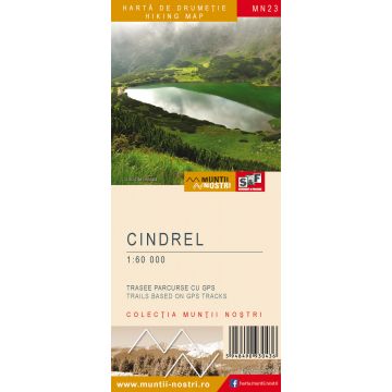
The Cindrel Mountains are a mountain group in the Southern Carpathians, bordered to the north and east by the Ampoi Corridor, Saliste Depression and Sibiu Depression; to the south by Sadu Valley, Steflesti Saddle and Frumoasa Valley, making the transition to Lotrului Mountains; to the west by Sebes Valley making the transition to Sureanu Mountains. The geology of Cindrel Mountains consists of hard rocks (crystalline schist) with a rugged landscape, crossed by valleys with steep slopes, where sometimes spectacular gorge sections are formed. The highest peaks are Cindrel Peak 2,243 m, Serbota Mare Peak 2,007 m, and Rozdesti Peak 1,817 m. The most important tourist attractions are the oldest and the highest mountain resort in the country, Paltinis, at an elevation of 1,450 m. The extensive pastures and the springs have led to the organization of numerous sheepfolds and so the Cindrel Mountains are considered to be one of the most important pastoral regions in the Romanian Carpathians. There are several nature reserves that are worth visiting, such as the Botanical Nature Reserve of Iezerele Cindrelului and Cindrel Natural Park. The map of Cindrel Mountains (MN23) is the 23rd map of the new Muntii Nostri collection. The map was edited using the latest mapping techniques and it was printed on moisture resistant paper. It is easy to read and simple to use due to the mapping styles, specific to Schubert & Franzke company, and as a result of practical information structuring. It is handy and everything is exactly where it should be. The map is useful for both hiking enthusiasts and professionals. All the trails have been recorded in the field using a GPS. They are described in detail in both Romanian and English, some trails having representative images attached to them. Each trail has a technical box containing: trail marking checked in the field, trail route, profile with major landmarks, data on difficulty, length, total ascent, total descent, round-trip time, practicability depending on the season and so on. The map also contains the UTM grid, a projected coordinate metric system useful in the quick measurement of distances on the map. Shading and contour lines highlight the landscape and facilitate orientation.
The Cindrel Mountains are a mountain group in the Southern Carpathians, bordered to the north and east by the Ampoi Corridor, Saliste Depression and Sibiu Depression; to the south by Sadu Valley, Steflesti Saddle and Frumoasa Valley, making the transition to Lotrului Mountains; to the west by Sebes Valley making the transition to Sureanu Mountains. The geology of Cindrel Mountains consists of hard rocks (crystalline schist) with a rugged landscape, crossed by valleys with steep slopes, where sometimes spectacular gorge sections are formed. The highest peaks are Cindrel Peak 2,243 m, Serbota Mare Peak 2,007 m, and Rozdesti Peak 1,817 m. The most important tourist attractions are the oldest and the highest mountain resort in the country, Paltinis, at an elevation of 1,450 m. The extensive pastures and the springs have led to the organization of numerous sheepfolds and so the Cindrel Mountains are considered to be one of the most important pastoral regions in the Romanian Carpathians. There are several nature reserves that are worth visiting, such as the Botanical Nature Reserve of Iezerele Cindrelului and Cindrel Natural Park. The map of Cindrel Mountains (MN23) is the 23rd map of the new Muntii Nostri collection. The map was edited using the latest mapping techniques and it was printed on moisture resistant paper. It is easy to read and simple to use due to the mapping styles, specific to Schubert & Franzke company, and as a result of practical information structuring. It is handy and everything is exactly where it should be. The map is useful for both hiking enthusiasts and professionals. All the trails have been recorded in the field using a GPS. They are described in detail in both Romanian and English, some trails having representative images attached to them. Each trail has a technical box containing: trail marking checked in the field, trail route, profile with major landmarks, data on difficulty, length, total ascent, total descent, round-trip time, practicability depending on the season and so on. The map also contains the UTM grid, a projected coordinate metric system useful in the quick measurement of distances on the map. Shading and contour lines highlight the landscape and facilitate orientation.
Weight:
66 g
Publisher:
Series:
Scale:
1:60.000
Product Type:
Maps
Language:
English, Romanian
EAN:
5948490930436
Year of publication:
2019
Write Your Own Review
Manufacturer
Name:
Address:
Email:
Phone:
Responsible for the EU
Name:
Address:
Email:
Phone:
Hazard warning:
Product Type: