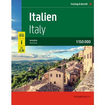
Italien, Autoatlas 1:150.000, freytag & berndt
Spiralbindung, Camping- und Stellplätze, Freizeitinfos
€36.90
incl. VAT
in stock
Delivery in 2 to 4 business days
Tags
Der Straßenatlas Italien 1:150.000 ist der richtige Begleiter für alle Urlauber die Italien mit dem Auto entdecken und das Dolce Vita auch links und rechts der Autobahn kennenlernen wollen. Er ist ideal für die Planung und erweist sich auch während der Reise als unverzichtbare Orientierungshilfe.
Informationen zum Straßenatlas Italien- Maßstab 1:150.000
- Spiralbindung verdeckt
- Touristische Informationen
- Ortsregister mit Postleitzahlen
- Camping- und Stellplätze
- 24 Innenstadtpläne
- 528 Seiten, Format 23.5 x 29,7 cm
Verdeckte Spiralbindung
Innenstadtpläne
Weight:
1,17 kg
Publisher:
Scale:
1:150000
Product Type:
Maps
EAN:
9783707924527
hoehe_mm:
298
breite_mm:
240
Year of publication:
2026
Write Your Own Review
Manufacturer
Name: KOMPASS Karten
Address: Karl-Kapferer-Str. 5, 6020 Innsbruck, Österreich
Email: info@kompass.at
Phone: +43 512 265561-10
Responsible for the EU
Name:
Address:
Email:
Phone:
Hazard warning: nicht erforderlich.
Product Type: