The store will not work correctly when cookies are disabled.
-
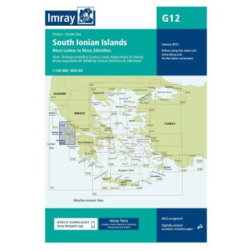
- Imray Seekarte Griechenland G12, South Ionian Islands 1:190.000
Imray Seekarte Griechenland G12, South Ionian Islands 1:190.000
Nisos Levkas to Nisos Zakinthos, 1:190.000
Imray Seekarte Griechenland G12, South Ionian Islands 1:190.000
Nisos Levkas to Nisos Zakinthos, 1:190.000
€31.90
incl. VAT
in stock
Delivery in 2 to 4 business days
Tags Mittelmeer Balkan Balkanhalbinsel greece Griechische Insel Seekarte Segeln Itháki nautical Chart Griechische Westküste Lefkas Kefallinía Nautik Chart Nautical Nautic Approach Mooring
Manufacturer Name: FB Imray Laurie Norie & Wilson GmbH
Address: Ölzeltgasse 3/10, 1030 Wien, Österreich
Phone:
Responsible for the EU Name:
Address:
Email:
Phone:
No manufacturer information and safety instructions available yet. Other customers also bought
If you are a reseller, please contact our
Wholesale departement directly.
Austria + GermanyT.
+43-1-869 90 90-800 sales.at@freytagberndt.com
When ordering through our webshop, end-customer prices are applied and a subsequent correction is unfortunately not possible.
freytag & berndt Sales Team