€9.90
incl. VAT
deliverable
Delivery in 1 to 4 business days
Tags
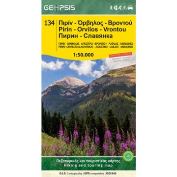
Pirin Mountain Range Map 1:50.000
It's said that the Pirin Mountainrange is the Alps of the Balkan! That's no random declaration and we believe words are not enough to describe. Take a look at the photos below or visit it's Discover page.
This is a hiking, biking and MTB, road and touring map. It contains trails, climbing areas and fields, proposals for trekking, points and areas of beautiful and protected Nature sites as well as sightseeing, while it imprints all Colored Waymarked Routes starting from each mountain hut.
70x100cm, folded 12x24cm, Scale 1:50.000
Printed on the waterproof and indestructible material 'Polyart'
The Back side is the map of a series of Mountains right to the south of Pirin in Greece.
3D Terrain, contour interval at 20m
Covering Pirin, Orvilos (Slavyanka), Vrontou, Lailias, Menoikio, Agκistro and more.
Weight:
73 g
Publisher:
Series:
Scale:
1:50.000
Product Type:
Maps
Language:
Bulgarian, English, Modern Greek
EAN:
9789609960274
Year of publication:
2016
Write Your Own Review
Manufacturer
Name:
Address:
Email:
Phone:
Responsible for the EU
Name:
Address:
Email:
Phone:
Hazard warning:
Product Type: