The store will not work correctly when cookies are disabled.
JavaScript scheint in Ihrem Browser deaktiviert zu sein. Um unsere Website in bester Weise zu erfahren, aktivieren Sie Javascript in Ihrem Browser.
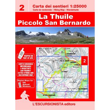
Escursionista-Karte 2, La Thuile, Piccolo San Bernardo 1:25.000 Escursionista-Karte 2, La Thuile, Piccolo San Bernardo 1:25.000
Escursionista-Karte 2, La Thuile, Piccolo San Bernardo 1:25.000 € 11,90
inkl. MwSt.
lagernd
Lieferung in 4 bis 7 Werktagen
Mehr aus der Reihe: Carta dei sentieri 1:25.000 Bitte wählen Sie Carta dei sentieri 17, Alte Valli di Lanzo 1:25.000 Carta dei sentieri 4, Conca di Aosta 1:25.000 Carta dei sentieri 5, Gran San Bernardo, Valle di Ollomont 1:25.000 Carta dei sentieri 9, Valsavarenche, Gran Paradiso 1:25.000 Carta dei sentieri Parco Nazionale del Gran Paradiso 1:25.000 Carta dei sentieri Parco Nazionale del Gran Paradiso 1:25.000 Escursionista-Karte 01, La Thuile, Haute Tarentaise 1:25.000 Escursionista-Karte 02, Tignes, Val d'Isère, Vallées du Grand Paradis 1:25.000 Escursionista-Karte 04, Saint-Gervais, Val Montjoie 1:25.000 Escursionista-Karte 1, Monte Bianco/Mont Blanc, Courmayeur 1:25.000 Escursionista-Karte 10, Valle di Cogne, Gran Paradiso 1:25.000 Escursionista-Karte 11, Valle di Champorcher, Parco Mont Avic 1:25.000 Escursionista-Karte 12, Basse Valli d'Ayas e del Lys 1:25.000 Escursionista-Karte 13, Valle Centrale 1:25.000 Escursionista-Karte 15, Val Soana 1:25.000 Escursionista-Karte 16, Valchiusella, Valle Sacra 1:25.000 Escursionista-Karte 20, Dora Baltea Canavesana, Laghi d'Ivrea 1:25.000 Escursionista-Karte 21, Biellese Nord Ovest/Nordwest 1:25.000 Escursionista-Karte 29, Monviso 1:25.000 Escursionista-Karte 3, Valgrisenche, Val di Rhêmes, Valsavarenche 1:25.000 Escursionista-Karte 40, Isola d'Elba 1:25.000 Escursionista-Karte 41, Cinque Terre 1:25.000 Escursionista-Karte 50, Bernina, Valmalenco, Sondrio 1:25.000 Escursionista-Karte 6, Valpelline, Saint-Barthélemy 1:25.000 Escursionista-Karte 7, Valtournenche, Monte Cervino/Matterhorn 1:25.000 Escursionista-Karte 8, Monte Rosa, Ayas, Gressoney, Alagna 1:25.000 Escursionista-Karte 95, Media Valmarecchia 1:25.000 Escursionista-Karte 97, Valconca 1:25.000 Escursionista-Karte 98, Colline di Pesaro, Parco Monte San Bartolo 1:25.000 Escursionista-Karte 99, Colline di Rimini, Repubblica di San Marino 1:25.000 Escursionista-Karte Valle Maira 1:25.000 Hiking Map 03 BO, Alte valli del Sillaro, Idice, Zena e Savena 1:25.000 Tags Karte Map Italia Italy Valle d'Aosta Hiking Wandern Wanderungen Wanderwege Carta escursionistica topografisch Wanderkarte Outdoor Italienische Alpen Westalpen Vallée d'Aoste Tête du Rutor Petit St-Bernard Piccolo San Bernardo Testa del Rutor Courmayeur Mapas
Schreibe deine eigene Bewertung Hersteller Name:
Adresse:
E-Mail-Adresse:
Telefonnummer:
Verantwortlich für die EU Name:
Adresse:
E-Mail-Adresse:
Telefonnummer:
Noch keine Herstellerangaben und Sicherheitshinweise verfügbar.
Folge uns
4,9 basierend auf 1516 Bewertungen
Zahlungsarten
Kundenbewertungen
Falls Sie Wiederverkäufer sind bestellen Sie bitte direkt über unsere Auslieferung damit wir ihre Konditionen berücksichtigen können:Österreich + Deutschland +43-1-869 90 90-800 sales.at@freytagberndt.com
Bei Bestellung über unseren Webshop kommen ausschließlich Endkundenpreise zur Anwendung und eine nachträgliche Korrektur ist leider nicht möglich.
Ihr Team von freytag & berndt