The store will not work correctly when cookies are disabled.
JavaScript scheint in Ihrem Browser deaktiviert zu sein. Um unsere Website in bester Weise zu erfahren, aktivieren Sie Javascript in Ihrem Browser.
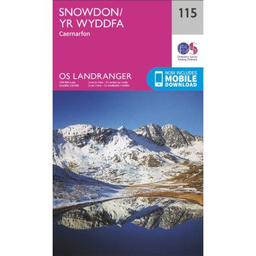
OS Landranger Map 115, Snowdon/Yr Wyddfa 1:50.000
OS Landranger Map 115, Snowdon/Yr Wyddfa 1:50.000 € 19,90
inkl. MwSt.
lieferbar
Lieferung in 5 bis 10 Werktagen
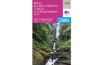
Mehr aus der Reihe: OS Landranger Bitte wählen Sie OS Landranger 111 Großbritannien - Sheffield & Doncaster 1:50.000 OS Landranger 119 Großbritannien - Buxton and Matlock, Bakewell and Dove Dale 1:50.000 OS Landranger 165 Großbritannien - Aylesbury & Leighton Buzzard 1:50.000 OS Landranger 166 Großbritannien - Luton & Hertford, Hitchin, St. Albans 1:50.000 OS Landranger 183 Großbritannien - Yeovil & Frome 1:50.000 OS Landranger 27 Großbritannien - Nairn, Forres 1:50.000 OS Landranger 29 Großbritannien - Banff & Huntly 1:50.000 OS Landranger 44 Großbritannien - Ballater & Glen Clova 1:50.000 OS Landranger 58 Großbritannien - Perth & Alloa 1:50.000 OS Landranger 66 Großbritannien - Edinburgh 1:50.000 OS Landranger Map 10, Strath Naver/Srath Nabhair 1:50.000 OS Landranger Map 100 Großbritannien - Malton & Pickering 1:50.000 OS Landranger Map 101 Großbritannien - Scarborough 1:50.000 OS Landranger Map 102 Großbritannien - Preston & Blackpool 1:50.000 OS Landranger Map 105, York & Selby 1:50.000 OS Landranger Map 106 Großbritannien - Market Weighton 1:50.000 OS Landranger Map 107 Großbritannien - Kingston OS Landranger Map 108 Großbritannien - Liverpool 1:50.000 OS Landranger Map 109 Großbritannien - Manchester 1:50.000 OS Landranger Map 11, Thurso & Dunbeath 1:50.000 OS Landranger Map 110 Großbritannien - Sheffield & Huddersfield 1:50.000 OS Landranger Map 113 Großbritannien - Grimsby 1:50.000 OS Landranger Map 114, Anglesey/Ynys Môn 1:50.000 OS Landranger Map 116 Großbritannien - Denbigh & Colwyn Bay 1:50.000 OS Landranger Map 116 Großbritannien - Denbigh & Colwyn Bay 1:50.000 OS Landranger Map 116, Denbigh & Colwyn Bay 1:50.000 OS Landranger Map 117 Großbritannien - Chester & Wrexham 1:50.000 OS Landranger Map 118 Großbritannien - Stoke-on-Trent & Macclesfield 1:50.000 OS Landranger Map 12, Thurso & Wick 1:50.000 OS Landranger Map 120 Großbritannien - Mansfield & Worksop 1:50.000 OS Landranger Map 121 Großbritannien - Lincoln & Newark-on-Trent 1:50.000 OS Landranger Map 123, Lleyn Peninsula/Pen Llyn 1:50.000 OS Landranger Map 124, Porthmadog & Dolgellau 1:50.000 OS Landranger Map 125, Bala & Lake Vyrnwy 1:50.000 OS Landranger Map 128 Großbritannien - Derby & Burton upon Trent 1:50.000 OS Landranger Map 129 Großbritannien - Nottingham & Loughborough 1:50.000 OS Landranger Map 13, West Lewis and North Harris 1:50.000 OS Landranger Map 130 Großbritannien - Grantham 1:50.000 OS Landranger Map 132 Großbritannien - North West Norfolk 1:50.000 OS Landranger Map 133, Haltwhistle & Brampton 1:50.000 OS Landranger Map 133, North East Norfolk 1:50.000 OS Landranger Map 134, Norwich & The Broads 1:50.000 OS Landranger Map 138, Kidderminster & Wyre Forest 1:50.000 OS Landranger Map 14, Tarbert & Loch Seaforth 1:50.000 OS Landranger Map 140 Großbritannien - Leiceter, Coventry & Rugby 1:50.000 OS Landranger Map 141 Großbritannien - Kettering & Corby 1:50.000 OS Landranger Map 143 Großbritannien - Ely & Wisbech 1:50.000 OS Landranger Map 146 Großbritannien - Lampeter & Llandovery 1:50.000 OS Landranger Map 147 Großbritannien - Elan Valley & Builth Wells 1:50.000 OS Landranger Map 15, Loch Assynt, Lochinver & Kylesku 1:50.000 OS Landranger Map 150 Großbritannien - Worcester & The Malverns 1:50.000 OS Landranger Map 151, Stratford-upon-Avon 1:50.000 OS Landranger Map 153 Großbritannien - Badford & Huntingdon 1:50.000 OS Landranger Map 154, Cambridge & Newmarket 1:50.000 OS Landranger Map 155 Großbritannien - Bury St Edmunds 1:50.000 OS Landranger Map 157, St Davids & Haverfordwest 1:50.000 OS Landranger Map 158 Großbritannien - Tenby & Pembroke 1:50.000 OS Landranger Map 159, Swansea & Gower 1:50.000 OS Landranger Map 16 Großbritannien - Lairg & Loch Shin 1:50.000 OS Landranger Map 160, Brecon Beacons/Bannau Brycheiniog 1:50.000 OS Landranger Map 163, Cheltenham & Cirencester 1:50.000 OS Landranger Map 164 Großbritannien - Oxford 1:50.000 OS Landranger Map 168 Großbritannien - Chelmsford 1:50.000 OS Landranger Map 168 Großbritannien - Colchester 1:50.000 OS Landranger Map 169 Großbritannien - Ipswich & The Naze 1:50.000 OS Landranger Map 17, Helmsdale & Strath of Kildonan 1:50.000 OS Landranger Map 172, Bristol & Bath 1:50.000 OS Landranger Map 173, Swindon & Devizes 1:50.000 OS Landranger Map 175, Reading & Windsor 1:50.000 OS Landranger Map 176 Großbritannien - West London 1:50.000 OS Landranger Map 177 Großbritannien - East London 1:50.000 OS Landranger Map 178, Thames Estuary 1:50.000 OS Landranger Map 179, Canterbury & East Kent 1:50.000 OS Landranger Map 18, Sound of Harris 1:50.000 OS Landranger Map 180, Barnstaple & Ilfracombe 1:50.000 OS Landranger Map 182 Großbritannien - Weston-Super-Mare 1:50.000 OS Landranger Map 185 Großbritannien - Winchester & Basingstoke 1:50.000 OS Landranger Map 186 Großbritannien - Aldershot & Guildford 1:50.000 OS Landranger Map 187, Dorking & Reigate 1:50.000 OS Landranger Map 188 Großbritannien - Maidstone & Royal Tunbridge Wells 1:50.000 OS Landranger Map 19, Gairloch & Ullapool, Loch Maree 1:50.000 OS Landranger Map 190, Bude & Clovelly 1:50.000 OS Landranger Map 191, Okehampton & North Dartmoor 1:50.000 OS Landranger Map 192, Exeter & Sidmouth 1:50.000 OS Landranger Map 193, Taunton & Lyme Regis 1:50.000 OS Landranger Map 195, Bournemouth & Purbeck 1:50.000 OS Landranger Map 196, The Solent & Isle of Wight 1:50.000 OS Landranger Map 198, Brighton & Lewes 1:50.000 OS Landranger Map 199, Eastbourne & Hastings 1:50.000 OS Landranger Map 20, Beinn Dearg & Loch Broom 1:50.000 OS Landranger Map 201, Plymouth & Launceston 1:50.000 OS Landranger Map 202, Torbay & South Dartmoor 1:50.000 OS Landranger Map 203, Land's End & Isles of Scilly 1:50.000 OS Landranger Map 22, Benbecula & South Uist 1:50.000 OS Landranger Map 23, North Skye - Dunvegan & Portree 1:50.000 OS Landranger Map 24, Raasay & Applecross 1:50.000 OS Landranger Map 25, Glen Carron & Glen Affric 1:50.000 OS Landranger Map 26, Inverness & Loch Ness 1:50.000 OS Landranger Map 3, Shetland - North Mainland 1:50.000 OS Landranger Map 30 Großbritannien - Fraserburgh 1:50.000 OS Landranger Map 31, Barra & South Uist 1:50.000 OS Landranger Map 32, South Skye & Cuillin Hills 1:50.000 OS Landranger Map 33, Loch Alsh, Glen Shiel & Loch Hourn 1:50.000 OS Landranger Map 34, Fort Augustus, Glen Albyn & Glen Roy 1:50.000 OS Landranger Map 36, Grantown & Aviemore 1:50.000 OS Landranger Map 37 Großbritannien - Strathdon & Alford 1:50.000 OS Landranger Map 38 Großbritannien - Aberdeen 1:50.000 OS Landranger Map 38 Großbritannien - Aberdeen 1:50.000 OS Landranger Map 40, Mallaig & Glenfinnan 1:50.000 OS Landranger Map 41, Ben Nevis, Fort William & Glen Coe 1:50.000 OS Landranger Map 42, Glen Garry & Loch Rannoch 1:50.000 OS Landranger Map 43, Braemar & Blair Atholl 1:50.000 OS Landranger Map 46 Großbritannien - Coll & Tiree 1:50.000 OS Landranger Map 47, Tobermory & North Mull 1:50.000 OS Landranger Map 48, Iona & West Mull 1:50.000 OS Landranger Map 5, Orkney - Northern Isles 1:50.000 OS Landranger Map 50, Glen Orchy & Loch Etive 1:50.000 OS Landranger Map 51, Loch Tay & Glen Dochart 1:50.000 OS Landranger Map 53 Großbritannien - Blairgowrie and Rattray 1:50.000 OS Landranger Map 54 Großbritannien - Dundee & Montrose 1:50.000 OS Landranger Map 55, Lochgilphead & Loch Awe 1:50.000 OS Landranger Map 56, Loch Lomond & Inveraray 1:50.000 OS Landranger Map 57, Stirling & The Trossachs 1:50.000 OS Landranger Map 59, St Andrews 1:50.000 OS Landranger Map 6, Orkney - Mainland 1:50.000 OS Landranger Map 60, Islay 1:50.000 OS Landranger Map 61, Jura & Colonsay 1:50.000 OS Landranger Map 64, Glasgow 1:50.000 OS Landranger Map 68, South Kintyre & Campbeltown 1:50.000 OS Landranger Map 69, Isle of Arran 1:50.000 OS Landranger Map 7, Orkney - Southern Isles 1:50.000 OS Landranger Map 70 Großbritannien - Ayr, Kilmarnock & Troon 1:50.00 OS Landranger Map 71, Lanark & Upper Nithsdale 1:50.000 OS Landranger Map 72 Großbritannien - Upper Clyde Valley 1:50.000 OS Landranger Map 73, Peebles, Galashiels and Selkirk 1:50.000 OS Landranger Map 74 Großbritannien - Kelso & Coldstream 1:50.000 OS Landranger Map 75 Großbritannien - Berwick upon Tweed 1:50.000 OS Landranger Map 76 Großbritannien - Girvan 1:50.000 OS Landranger Map 77 Großbritannien - Dalmellington & New Galloway 1:50.000 OS Landranger Map 78 Großbritannien - Nithsdale & Annandale 1:50.000 OS Landranger Map 79, Hawick & Eskdale 1:50.000 OS Landranger Map 8, Stornoway & North Lewis 1:50.000 OS Landranger Map 80 Großbritannien - Cheviot Hills & Kielder Water 1:50.000 OS Landranger Map 82 Großbritannien - Stranraer & Glenluce 1:50.000 OS Landranger Map 83, Newton Stewart & Kirkcudbright 1:50.000 OS Landranger Map 84, Dumfries & Castle Douglas 1:50.000 OS Landranger Map 85 Großbritannien - Carlisle & Solway Firth 1:50.000 OS Landranger Map 88 Großbritannien - Newcastle upon Tyne 1:50.000 OS Landranger Map 89, West Cumbria 1:50.000 OS Landranger Map 9, Cape Wrath, Durness & Scourie 1:50.000 OS Landranger Map 91, Appleby-in-Westmorland 1:50.000 OS Landranger Map 93 Großbritannien - Middlesbrough 1:50.000 OS Landranger Map 94, Whitby & Esk Dale 1:50.000 OS Landranger Map 95, Isle of Man 1:50.000 OS Landranger Map 97 Großbritannien - Kendal & Morecambe 1:50.000 OS Landranger Map 97 Großbritannien - Kendal & Morecambe 1:50.000 OS Landranger Map 98, Wensleydale & Upper Wharfedale 1:50.000 Saxmundham, Aldeburgh & Southwold 1:50.000 Tags Karte Map Vereinigtes Königreich Great Britain United Kingdom National Park Hiking Wandern topografisch Wanderkarte Outdoor cymru Irish Sea Ynys Môn Muir Éireann Yr Wyddfa Ordnance Survey Snowdonia-Nationalpark
Schreibe deine eigene Bewertung Hersteller Name:
Adresse:
E-Mail-Adresse:
Telefonnummer:
Verantwortlich für die EU Name:
Adresse:
E-Mail-Adresse:
Telefonnummer:
Noch keine Herstellerangaben und Sicherheitshinweise verfügbar.
Folge uns
0,0 basierend auf 0 Bewertungen
Zahlungsarten
Kundenbewertungen
Falls Sie Wiederverkäufer sind bestellen Sie bitte direkt über unsere Auslieferung damit wir ihre Konditionen berücksichtigen können:Österreich + Deutschland +43-1-869 90 90-800 sales.at@freytagberndt.com
Bei Bestellung über unseren Webshop kommen ausschließlich Endkundenpreise zur Anwendung und eine nachträgliche Korrektur ist leider nicht möglich.
Ihr Team von freytag & berndt