Gecko Hiking Map Japan, Asahi-Dake 1:25.000
von: Markus Hauser, Verlag: Gecko Maps

Tags
ISBN 978-3-906593-22-7
1. Auflage 2017
Wanderkarte 1:25.000
Recently, Japan welcomes rapidly increasing number of international tourists from all over the world. Daisetsuzan National Park, the largest mountain national park in Japan, located in the center of Hokkaido, northern part of Japan, is not the exception. There are increasing numbers of international tourists, hikers, climbers and skiers.
On the other hand, there are some concerns if such international visitors could be involved in future incidences during their stay in high mountain areas. The mountains of the Daisetsuzan National Park are as high as 2100 to 2290 m only. Nevertheless, the climate is really severe to have permafrost at high altitudes. There are unfortunate incidences in the park area every year.
Furthermore, the Ministry of the Environment, a responsible authority of the national park, launched the new trail grading system in the national park, which is called Daisetsuzan Grade. This indicates that each of the trail sections (in total 330 km in length) has different management conditions and offers different difficulties to walk. Understanding the Daisetsuzan Grade will be essential for all visitors to spend comfortable and safe time.
To avoid unnecessary injuries and even death incidences, we would like all international visitors to possess our English map.
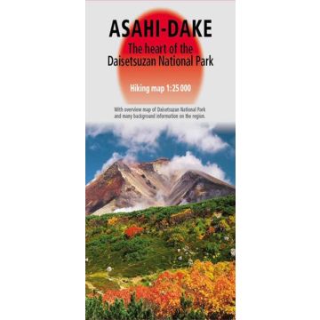
The map was created in close collaboration of Swiss and Japanese specialists and shows on one side in scale 1: 25,000 the main trekking area around the Onsen villages of Asahi-dake and Sonkyou with all aspects of a topographical map, including a hand-painted shadow relief. On the reverse side the user gets information on the Geography, Geology, Flora and Fauna of the area. Important information for visitors together with an overview map of the whole National Park and two detailed maps of Asahi-dake and Sonkyou complete the description.
Autor:
Verlag:
Maßstab:
1:25.000
Medienart:
Karten
Sprache:
Englisch
EAN:
9783906593227
Erscheinungsjahr:
2017
Kategorien: Wanderkarten Japan
