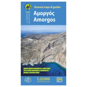
Anavasi Topo Island Map 10.27, Amorgós 1:35.000
Kykladen

Tags
A new and updated in 2022 hiking map of Amorgos island in a scale of 1:32 000, in English and French.
Amorgos Hiking map in scale 1:32 000 is updated with all new footpaths, roads, toponyms and even the diving center.
From above, Amorgos looks like a skeletal form whose ravines draw the bones, but as you get closer, the continual variations of the landscape become clearer, and make meaning: the archaeological sites of the first European societies, the Hellenistic towers, the monastery in the cliffs, the white houses, the multiple terraces, and modest chapels blessing all this improbable fertility. And then, the beds of small torrents retaining the freshness of water, the numerous wells, ancient cisterns and sources of fresh water overturn the initial impression. All these elements tell the story of the thousand-year-old cohabitation of man in the Cycladic landscape, a story of hard labour, but also of elevation towards a refined spirituality.
And the tale unfolds step by step, revealed to hikers who follow the centuries-old trails of the island.
The new edition is printed on synthetic paper (waterproof and rip-proof) is even more lightweight and very easy to carry.
Verlag:
Reihe:
Maßstab:
1:32.000
Medienart:
Karten
Sprache:
Deutsch, Englisch, Französisch, Italienisch, Neugriechisch
EAN:
9789608195318
Erscheinungsjahr:
2022