Sustrans Cycle Route Map Lochs & Glens South 1:100.000
Schottland

Tags
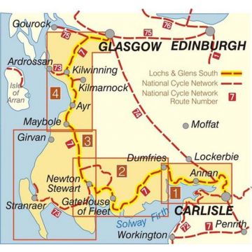
This area map shows the Lochs & Glens South cycle route and surrounding area over a series of map panels.
The map covers the southern half of the Lochs & Glens route, from Carlisle in Cumbria - Glasgow in Scotland via Ayr. The route leaves Glasgow and heads into the rolling hills and pastures of Ayrshire with exciting views towards Arran and the Clyde Coast. The dominant feature of this route is the huge Galloway Forest Park, 300 miles of rivers flow in its valleys and over 150 lochs are to be found amid the wild moorland and mountain crags. Leaving the forest means a descent to the Solway Coast, a haven for bird life and a final leg through Dumfries and Galloway.
This full colour map based on Ordnance Survey data shows clearly mapped cycle routes on traffic-free paths, quiet lanes and roads, with easy to read contours and route profiles. Also features detailed inset maps for the major towns and cities and suggested day rides.
National Cycle Network routes covered
National Route 7 between Carlisle and Glasgow
Published/Erscheinungsjahr: 2018
Miles/Distanz in Meilen: 215
Scale/Maßstab: 1:100,000
Size/Maße: 13 x 24 cm folded, 67 x 100 cm unfolded
Paper/Papier: Waterproof, comes in plastic cover
Kategorien: Radkarten