BlueChart g3 HXEU018R - Benelux Offshore and Inland Waters
microSD/SD

Tags
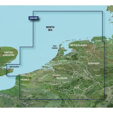
Detailed coverage of the lowest south-eastern coast of the UK, the North Sea coast of Europe and some of the most popular interior waterways of north-eastern France and the whole of Benelux. Coverage from Whitstable to Folkestone in the UK and Calais, FR to Emden, DE on the continental Europe including the Waddenzee, the IJsselmeer, the River Meuse, the Moselle River to Argancy and the Rhein River to Koblenz among the many other interior rivers and canals of the region. Ports include Dover in the UK, Amsterdam and Rotterdam in the Netherlands.
Produktdetails:
EAN: 9901000775206
Kategorien: Seekarten