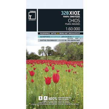
Terrain Map 328, Chíos (Híos) 1:60.000
Inousses Nördliche Ägäis

Tags
All major trails of Chios are shown, with distances measured in kilometres, so that you can estimate the duration of your hike. On the reverse side you ‘ll find detailed descriptions of 3 of the island’s best hikes. These are also distinctly labeled on the map, so you can easily locate them.
It includes a map of the neighboring island of Oinousses, showing all beaches and a detailed town plan of the island’s capital, in the scale of 1:4,000, with all sites of interest clearly indicated. It also shows more roads and hiking trails than any other map of Chios, with scenic routes marked in green.
It is printed on Polyart plastic material, making it totally waterproof and rip-proof. You can fold it and unfold it a hundred times, fold it in irregular ways, dunk it in the sea or leave it out in the rain. This map is indestructible!
The island’s entire coastline is mapped for the first time with TERRAIN’s specially equipped and staffed cartographic vessel. This means that you can locate all beaches of the island, down to the tiniest cove! In fact, the special features of every single beach are recorded: whether it is sandy or pebbled, whether it features natural tree shade, water, a beach bar or organized water sports, whether the seabed in front of the beach is sandy or rocky (so that you will know where to anchor).
It indicates the boundaries of NATURA 2000 areas so that you will know which parts of the island are of special environmental interest and beauty – thus you can enjoy traveling through them, but also take care to protect them.
For the first time, the best mountain-bike routes on Chios are indicated on a map. Moreover, the reverse side features an illustrated mini travel guide, with information on the island’s myths and history, geography and natural environment, sights and major attractions.
Scale/Maßstab: 1:60.000
Edition/Auflage: 2nd edition, June 2016
It is the only GIS map of Chios made with data collected 100% through field survey.
Verlag:
Reihe:
Maßstab:
1:60.000
Medienart:
Karten
Sprache:
Englisch, Neugriechisch
EAN:
9789609456043
Erscheinungsjahr:
2016
Kontinent: Europa
Land: Griechenland